IGS Symposium Sessions
GNSS Infrastructure and Data Integrity in a Multi-Constellation Era (Chairs: Markus Bradke, Ryan Ruddick, Francesco Gini)
From Orbits to Reference Frames: Advances in GNSS Processing (Chairs: Paul Rebischung, Taylor Yates, Bingbing Duan, Arturo Villiger, Peter Steigenberger )
Real-Time GNSS Services and Next-Generation Positioning (Chairs: Axel Rülke, Mike Coleman, Jianghui Geng)
GNSS as a Sensor of the Atmosphere and Space Weather (Chairs: Andrzej Krankowski, Sharyl Byram, Victor Pinto, João Francisco Galera Monico)
GNSS for Society: Geohazards, Climate Change, Sustainability and Beyond (Chair: Allison Craddock, Fernand Bale, Attila Komjathy)
IGS 2026 eBook
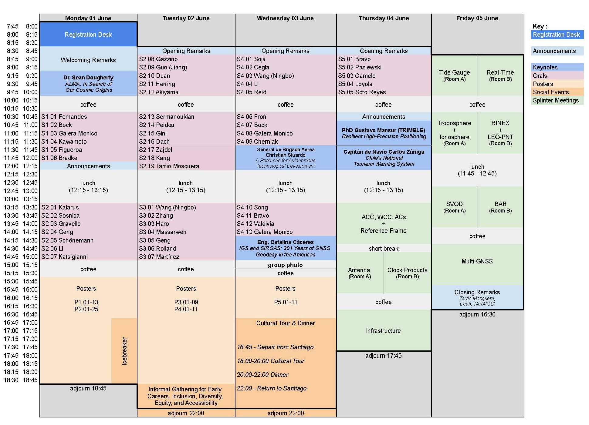
Program

IDEA = Informal Gathering for Early Careers, Inclusion, Diversity, Equity, and Accessibility.
Irish Geo Pub. Encomenderos 179 street. Las Condes. Santiago, Chile.
This is an informal networking activity open to all interested participants and provides an excellent opportunity to connect with colleagues, exchange experiences, and continue discussions in a relaxed setting.
Please note that attendance is optional and that all food and beverage expenses will be at each participant’s own expe
Cultural Tour & Dinner = Casillero del Diablo Night Experience
Viña Concha y Toro. Av. Virginia Subercaseaux 210, Pirque. Santiago – Chile
Schedule
16:45 – Departure to the Winery
18:00 – Arrival at the winery and welcome
Guided Winery Tours (departures every 10 minutes)
18:10 – Group A
18:20 – Group B
18:30 – Group C
Wine Store Experience (departures every 10 minutes)
19:30 – Group A
19:40 – Group B
19:50 – Group C
20:00 – Dinner at Bodega 1883 Restaurant
A carefully crafted dining experience inspired by Chilean flavors
22:00 – Return to Santiago
Session details
| Session | Presentation ID | Presenting Author | Presentation Title | Institution | Country |
|---|---|---|---|---|---|
| Keynote Lectures | K1 | Dr. Sean Dougherty | ALMA: In Search of Our Cosmic Origins | Atacama Large Millimeter/submillimeter Array | CHILE |
| K2 | Dr. Gustavo Mansur | Resilient High-Precision Positioning: From Mitigating Signal Interference to Modeling Complex Crustal Deformation | Trimble | BRAZIL | |
| K3 | General de Brigada Aérea Christian Stuardo | National Space Program: A Roadmap for Autonomous Technological Development | National Space Program | CHILE | |
| K4 | Dr. Catalina Cáceres | IGS and SIRGAS: 30+ Years of GNSS Geodesy in the Americas | USACH | CHILE | |
| K5 | Capitán de Navío Carlos Zúñiga | Chile's National Tsunami Warning System | Servicio Hidrográfico y Oceanográfico de la Armada de Chile | CHILE | |
| 1 | S1 01 Fernandes | Dr. Rui Fernandes | Metadata Harmonization of GNSS Data Repositories | SEGAL (University of Beira Interior, Institute Dom Luíz) | PORTUGAL |
| 1 | S1 02 Bock | Dr. Olivier Bock | The Critical Role of GNSS Metadata in Ensuring Homogeneous Time Series for Geophysical Applications | IPGP - IGN | FRANCE |
| 1 | S1 03 Galera Monico | Prof. João Francisco Galera Monico | The legacy of the INCT GNSS NavAer: historic, infrastructure and data set. | Universidade Estadual Paulista - Unesp | BRAZIL |
| 1 | S1 04 Kawamoto | Dr. Satoshi Kawamoto | Modernizing Multi-GNSS data pre-processing tools: RINGO and RNXCMP Updates with RINEX 4.02 format compatibility | Geospatial Information Authority of Japan | JAPAN |
| 1 | S1 05 Figueroa | Dr. Mara Figueroa | GeoDE: the Geodesy Database Engine for GNSS Data Processing, Management, and Trajectory Analysis | NASA Jet Propulsion Laboratory, California Institute of Technology | UNITED STATES |
| 1 | S1 06 Bradke | Mr. Markus Bradke | A Cloud-Native GNSS Data Lakehouse for Scalable Ingestion, Processing, and Analysis | GFZ | GERMANY |
| 1 | P1 01 Miyahara | Mr. Basara Miyahara | IGS Analysis Center “JGX” – Evaluation of Products Performance | Geospatial Information Authority of Japan | JAPAN |
| 1 | P1 02 Jolivet | Dr. Laurent Jolivet | Monitoring Emerging Galileo Services through the REGINA GNSS Global Network | CNES | FRANCE |
| 1 | P1 03 Ramatschi | Mr. Markus Ramatschi | Recent Developments in GFZ’s GNSS Contributions: Network, Realtime, and the GIPP Instrument Pool | GFZ | GERMANY |
| 1 | P1 04 Imada | Ms. Emi Imada | Overview of MADOCA: Architecture and Recent Developments | JAXA | JAPAN |
| 1 | P1 05 Sermanoukian | Mr. Ivan Sermanoukian Molina | EGON: The ESA/ESOC GNSS Observation station Network | CSC Ltd | UNITED KINGDOM |
| 1 | P1 06 Mu | Dr. Lei Mu | Autonomous Time Synchronization and Reference Maintenance in LEO Satellite Constellations | Shanghai Astronomical Observatory | CHINA |
| 1 | P1 07 Schönemann | Dr. Erik Schönemann | GSSC: GNSS Science Support Centre - ESA’s IGS Global Data Centre | ESA | GERMANY |
| 1 | P1 08 de Seixas | Prof. Dr. Andrea de Seixas | GNSS Data Robustness and Resilience: The Recife Multi-GNSS Experimental Nucleus for Autonomous Assessment of PNT Service Performance, Integrity and Continuity | Associação Instituto de Tecnologia de Pernambuco - ITEP | BRAZIL |
| 1 | P1 09 de Seixas | Prof. Dr. Andrea de Seixas | Technological Evolution of a GLONASS Ground Segment Station Located in Recife, PE, Brazil | Associação Instituto de Tecnologia de Pernambuco - ITEP | BRAZIL |
| 1 | P1 10 Voltare Zaupa | Mr. João Pedro Voltare Zaupa | Stability and Convergence Gains from Multi-Constellation GNSS in Precise Point Positioning Using 2 Hz Data | FCT UNESP | BRAZIL |
| 1 | P1 11 Galera Monico | Prof. João Francisco Galera Monico | Assessing the Quality of IGS Final and Rapid Products via PPP-AR Derived Solutions | Universidade Estadual Paulista | BRAZIL |
| 1 | P1 12 Spesivtsev | Mr. Aleksandr Spesivtsev | Cloud-based GNSS data processing at GeoNet: Navigating the migration | Earth Sciences New Zealand | NEW ZEALAND |
| 2 | S2 01 Kalarus | Dr. Maciej Kalarus | Experimental CODE products based on GPS L1/L5 signals | University of Bern, Astronomical Institute | SWITZERLAND |
| 2 | S2 02 Sosnica | Prof. Krzysztof Sosnica | Improving GNSS positioning by clock constraints | Institute of Geodesy and Geoinformatics, Wrocław University of Environmental and Life Sciences | POLAND |
| 2 | S2 03 Gravelle | Mr. Mederic Gravelle | Comparison of GPS-only and Galileo-only ambiguity-fixed PPP solutions: insights from the SPOTGINS analysis center | LIENSs | FRANCE |
| 2 | S2 04 Geng | Prof. Jianghui Geng | Consistent in-orbit calibration of all-frequency BDS-3 satellite antenna phase centers and their implications for the terrestrial reference frame scale | State Key Laboratory of Precision Geodesy, APM, CAS, Wuhan | CHINA |
| 2 | S2 05 Schönemann | Dr. Erik Schönemann | ESA Code Bias Reference Frame | European Space Agency | GERMANY |
| 2 | S2 06 Guo (Jing) | Prof. Jing Guo | BDS-3 high-accuracy products based on modernized B1C and B2a signals: the threat of pilot–mixed channel and signal distortion biases | Wuhan University | CHINA |
| 2 | S2 07 Katsigianni | Dr. Georgia Katsigianni | IDEFIX: An algorithm for the comparison and validation of fixed ambiguities | Collecte Localisation Satellites (CLS) | FRANCE |
| 2 | S2 08 Gazzino | Dr. Clément Gazzino | GNSS satellite hardware biases stability over time: long term analysis of the products from several analysis centers and impact from flex power. | CNES | FRANCE |
| 2 | S2 09 Guo (Jiang) | Dr. Jiang Guo | Continuous and multi-GNSS IPPP link for UTC | BIPM | FRANCE |
| 2 | S2 10 Duan | Mr. Bingbing Duan | Toward a standardized GNSS satellite attitude modeling framework | Technical University of Munich | GERMANY |
| 2 | S2 11 Herring | Prof. Thomas Herring | IGS ACC Transition and Development of Multi-GNSS Operational Products | IGS ACC (NASA / SSAI) | UNITED STATES |
| 2 | S2 12 Akiyama | Mr. Kyohei Akiyama | Precise Orbit Determination of QZSS Satellites Integrated with LEO Onboard GNSS Observations | Japan Aerospace Exploration Agency | JAPAN |
| 2 | S2 13 Sermanoukian | Mr. Ivan Sermanoukian Molina | Making It COOL: Enhancing ESA’s COmbination at the Observation Level | VisionSpace Technologies | GERMANY |
| 2 | S2 14 Peidou | Dr. Athina Peidou | Integrating Four Space Geodetic Techniques for Terrestrial Reference Frame Recovery | NASA Jet Propulsion Laboratory, California Institute of Technology | UNITED STATES |
| 2 | S2 15 Gini | Dr. Francesco Gini | Genesis: Status and performance analysis of the GNSS instrument | European Space Agency | GERMANY |
| 2 | S2 16 Dach | Mr. Rolf Dach | ESA’s Genesis mission: Implications for the IGS GNSS analysis | Astronomical Institute, University of Bern | SWITZERLAND |
| 2 | S2 17 Zajdel | Dr. Radosław Zajdel | Three Decades of GNSS-Derived Geocenter Motion | Geodetic Observatory Pecný (GOP) | CZECH REPUBLIC |
| 2 | S2 18 Kang | Dr. Zhigui Kang | Earth’s Gravitational Coefficient GM and Geocenter Motion Determination using LEO GPS Data | Center of Space Research, The University of Texas at Austin | UNITED STATES |
| 2 | S2 19 Tarrío Mosquera | Dr. José Antonio Tarrío Mosquera | Time-Dependent GNSS Reference Frames in Tectonically Active Regions: The ADELA Approach within SIRGAS | USACH | CHILE |
| 2 | P2 01 Dach | Mr. Rolf Dach | Activities at the CODE Analysis Center | Astronomical Institute, University of Bern | SWITZERLAND |
| 2 | P2 02 Kobel | Dr. Cyril Kobel | Advancing Zero-Difference GNSS Processing for Operational Use at Center for Orbit Determination in Europe (CODE) | Astronomical Institute, University of Bern | SWITZERLAND |
| 2 | P2 03 Brockmann | Dr. Elmar Brockmann | Quality Monitoring of Multi-GNSS Product Series at the CODE Analysis Center | University of Bern | SWITZERLAND |
| 2 | P2 04 Banville | Mr. Simon Banville | Next-Generation GNSS Precise Orbit Determination (POD) Software for the EMR Analysis Center | Natural Resources Canada (NRCan) | CANADA |
| 2 | P2 05 Gini | Dr. Francesco Gini | ESA IGS Analysis Centre – Status Update | SSC Space GmbH | GERMANY |
| 2 | P2 06 Männel | Dr. Benjamin Männel | Recent developments of EPOS software at GFZ: GNSS and LEO integrated data processing | GFZ Helmholtz Centre for Geosciences, Potsdam, Germany | GERMANY |
| 2 | P2 07 Loyer | Mr. Sylvain Loyer | CNES/CLS IGS Analysis Center 2024/2026 Activities | CLS | FRANCE |
| 2 | P2 08 Ries | Dr. Paul Ries | Testing new Empirical SRP Models at the JPL IGS Analysis Center | NASA Jet Propulsion Laboratory, California Institute of Technology | UNITED STATES |
| 2 | P2 09 McFarland | Mr. Phillip McFarland | Genetic Algorithm Optimization of GNSS Ground Tracking Networks for Orbit Determination | NOAA / NGS | UNITED STATES |
| 2 | P2 10 Tan | Dr. Weijie Tan | GNSS Determination of EOP at 12-Hour Resolution | Shanghai Astronomical Observatory, Chinese Academy of Sciences, Shanghai, China | CHINA |
| 2 | P2 11 Zajdel | Dr. Radosław Zajdel | Beyond Constellations: Revealing Natural Satellite Groups in Multi-GNSS Landscape | Geodetic Observatory Pecný (GOP) | CZECH REPUBLIC |
| 2 | P2 12 Barnéoud | Mr. Julien Barnéoud | Midnight discontinuities in repro3 orbits: what can we learn about solar radiation pressure mismodeling? | IGN-IPGP | FRANCE |
| 2 | P2 13 Yang | Dr. Chao Yang | Contribution of BDS-3 Inter-Satellite Links to Geocenter Motion Derived from GNSS | Hong Kong Polytechnic university | CHINA |
| 2 | P2 14 Wang (Xiaoya) | Prof. Xiaoya Wang | GRACE-FO Real-Time Precise Orbit Determination with Onboard GPS and Inter-Satellite Ranging Measurements Based on DIA Quality Control Algorithm | Shanghai Astronomical Observatory, Chinese Academy of Sciences | CHINA |
| 2 | P2 15 Yezhi | Prof. Song Yezhi | Precise Orbit Determination and Spacetime Transformation for Autonomous Navigation in the Earth-Moon Space | Shanghai Astronomical Observatory, Chinese Academy of Sciences | CHINA |
| 2 | P2 16 Wang (Bin) | Dr. Bin Wang | Developing a time scale for multi-GNSS clock products | Shanghai Astronomical Observatory, Chinese Academy of Sciences | CHINA |
| 2 | P2 17 Schönemann | Dr. Erik Schönemann | An Update on Genesis Mission Status | ESA Directorate of Navigation, ESA/ESTEC, Noordwijk, The Netherlands | NETHERLANDS ANTILLES |
| 2 | P2 18 Abe | Mr. Satoshi Abe | Initiative for Estimating the QZSS Reference Frame | Geospatial Information Authority of Japan | JAPAN |
| 2 | P2 19 Byram | Dr. Sharyl Byram | Status of the IERS Conventions Updates | USNO | UNITED STATES |
| 2 | P2 20 Rebischung | Dr. Paul Rebischung | pytrf: a Python toolbox for the analysis of time series and terrestrial reference frames | IGN-IPGP | FRANCE |
| 2 | P2 21 Rebischung | Dr. Paul Rebischung | Generating realistic synthetic GNSS station position time series to evaluate automatic discontinuity detectors | IGN-IPGP | FRANCE |
| 2 | P2 22 Männel | Dr. Benjamin Männel | Impact of surface loading deformation on GNSS products | GFZ Helmholtz Centre for Geosciences | GERMANY |
| 2 | P2 23 Fang | Dr. Peng Fang | Intra-frame deformation model (IFDM) for the Western U.S. | Scripps Institution of Oceanography | UNITED STATES |
| 2 | P2 24 Tarrío Mosquera | Dr. José Antonio Tarrío Mosquera | Application of IGS Products to the Development of Kinematic Reference Frames in Seismically Active Regions: The SIRGAS-CON Network | USACH | CHILE |
| 2 | P2 25 Cisneros Revelo | Mr. David Alexander Cisneros Revelo | SIRGAS Ecuador Geodetic Reference Frame ITRF 2020, VEC EC 2025 Velocity Field | Instituto Geografico Militar | ECUADOR |
| 3 | S3 01 Wang (Ningbo) | Dr. Ningbo Wang | CAS real-time multi-GNSS clock and bias estimation: new product streams for precise point positioning with ambiguity resolution | Aerospace Informatioin Research Institute, Chinese Academy of Sciences | CHINA |
| 3 | S3 02 Zhang | Dr. Yize Zhang | Real-time multi-GNSS orbit and clock combination at SHAO | Shanghai Astronomical Observatory | CHINA |
| 3 | S3 03 Haro | Mrs. Mónica Zabala Haro | SIRGAS Regional Experimental Caster: Architecture, Operation and Perspectives for Real-Time GNSS Services | Escuela Superior Politécnica de Chimborazo | ECUADOR |
| 3 | S3 04 Massarweh | Dr. Lotfi Massarweh | Analysis of uncertainty information of real-time SSR corrections from a regional network and impact on PPP-AR | Delft University of Technology | NETHERLANDS |
| 3 | S3 05 Geng | Prof. Jianghui Geng | One-Hz real-time multi-GNSS satellite phase clocks for global rapid geohazard response | State Key Laboratory of Precision Geodesy, APM, CAS, Wuhan | CHINA |
| 3 | S3 06 Rolland | Dr. Lucie Rolland | Strengthening Pacific Tsunami Early Warning through GNSS: Insights from Kamchatka 2025 event and the GeTEWS Oceania Initiative | Observatoire de la Côte d'Azur | FRANCE |
| 3 | S3 07 Martínez | Mr. Alejandro Martínez | Comparison of elevations obtained through geometric leveling and real-time GNSS positioning to support of bathymetric surveys | INOCAR | ECUADOR |
| 3 | P3 01 Stürze | Ms. Andrea Stürze | Developments within the IGS Real-Time Service towards PPP-AR | Federal Agency for Cartography and Geodesy (BKG) | GERMANY |
| 3 | P3 02 Hassen | Mr. Elyes Hassen | From IGS Products to User Solutions: Canada’s CSRS-PPP Service | Natural Resources Canada | CANADA |
| 3 | P3 03 Rodríguez | PhD. Felipe Carvajal Rodríguez | Trimble's support for modernized datums in Chile, validated through GNSS Precise Point Positioning | USACH | CHILE |
| 3 | P3 04 Milanowska | Miss Beata Milanowska | Exploring the current accuracy of the multi-GNSS SPP solution for mass-market applications | University of Warmia and Mazury in Olsztyn | POLAND |
| 3 | P3 05 Vaclavovic | Dr. Pavel Vaclavovic | Assessment of the Galileo High Accuracy Service in real time based on observed data | Research Institute od Geodesy, Topography, and Cartograhy, Geodetic Observatory Pecny | CZECH REPUBLIC |
| 3 | P3 06 Camisay | Dr. Maria Fernanda Camisay | Experimental study of real time multi-constellation PPP, applied to SIRGAS GNSS stations in Uruguay | Facultad de Ingeniería, UDELAR | URUGUAY |
| 3 | P3 07 Białas | Mr. Jakub Białas | Multi-GNSS clock combination with refined clock alignment and code-phase bias integration for Precise Point Positioning | Wrocław University of Environmental and Life Sciences | POLAND |
| 4 | S4 01 Soja | Prof. Benedikt Soja | Probabilistic Neural Networks for Tropospheric and Ionospheric Delays with Calibrated Uncertainties in GNSS Positioning | ETH Zurich | SWITZERLAND |
| 4 | S4 02 Cegla | Dr. Adam Cegla | Deep learning-based GNSS tomography for high-resolution tropospheric monitoring | ETH Zurich | POLAND |
| 4 | S4 03 Wang (Ningbo) | Dr. Ningbo Wang | RT-FAIRS: Real-time Factor-Adjusted Ionospheric Residual Statistics approach for generating accuracy information in Global Ionospheric Maps | Aerospace Informatioin Research Institute, Chinese Academy of Sciences | CHINA |
| 4 | S4 04 Li | Dr. Haobo Li | Recent Advances in Ground-based GNSS Atmospheric Monitoring: New Datasets, Innovative Methodologies, and Emerging Applications | RMIT University | AUSTRALIA |
| 4 | S4 05 Reid | Dr. Benjamin Reid | Real-Time Ionospheric Products From the TOMIRIS Data Assimilation Model | University of Birmingham | UNITED KINGDOM |
| 4 | S4 06 Froń | Dr. Adam Froń | Assimilation of Climate-Scale TEC Maps, Low-Latency GNSS Products, and Auroral Oval in the IGS–IRI Cooperation | University of Warmia and Mazury in Olsztyn | POLAND |
| 4 | S4 07 Bock | Dr. Olivier Bock | Assessing and improving the accuracy of GNSS tropospheric products for climate research | IPGP - IGN | FRANCE |
| 4 | S4 08 Galera Monico | Prof. João Francisco Galera Monico | Assessment of Climate Variability and Extreme Events Using GNSS-Based PWV | FCT UNESP | BRAZIL |
| 4 | S4 09 Cherniak | Dr. Iurii Cherniak | IGS ROTI Maps: 10+ years of operational history, current status, and perspectives | SRRC UWM | POLAND |
| 4 | S4 10 Song | Prof. Shuli Song | Ionosphere Research Activities at SHAO | Shanghai Astronomical Observation, Chinese Academy of Sciences, Shanghai, China | CHINA |
| 4 | S4 11 Bravo | Dr. Manuel Bravo | Using GNSS TEC to Monitor Ionospheric Responses to Solar Eclipses | Centro de Instrumentación Científica, Universidad Adventista de Chile | CHILE |
| 4 | S4 12 Valdivia | Dr. Juan Valdivia | Spatial correlations between GNSS derived TEC and position errors for geophysical applications | Departamento de Física, Facultad de Ciencias, Universidad de Chile | CHILE |
| 4 | S4 13 Galera Monico | Prof. João Francisco Galera Monico | Monitoring Ionospheric Irregularities in Brazil Using Multifrequency and Multiconstellation GNSS Data | UTFPR (Federal University of Technology - Paraná) | BRAZIL |
| 4 | P4 01 Guerova | Dr. Guergana Guerova | GNSS severe weather monitoring in Southeast Europe: progress and prospects | Sofia University "St. Kliment Ohridski" | BULGARIA |
| 4 | P4 02 Stepniak | Dr. Katarzyna Stepniak | Assessment of tropospheric parameter estimation using the Centipede-RTK low-cost GNSS network in a mountainous area | University of Warmia and Mazury in Olsztyn | POLAND |
| 4 | P4 03 Hernández Inostroza | Mrs. Jorge Francisco Hernández Inostroza | Snow accumulation and ablation patterns estimated using GNSS-IR in the Mocho-Choshuenco volcanic complex, Southern Andes | Universidad Austral de Chile | CHILE |
| 4 | P4 04 Camisay | Dr. Maria Fernanda Camisay | Long-Term Analysis of SIRGAS ZTD Time Series for Early Anomaly Detection | Facultad de Ingeniería, UDELAR | URUGUAY |
| 4 | P4 05 Calderon Montoya | Mr. Wilder Jaime Calderon Montoya | VTEC Forecasting Using Machine Learning Under Varying Geospace Conditions | EXAGONE | PERU |
| 4 | P4 06 Khripunov | Mr. Ivan Khripunov | Real-time local ionospheric model based on double-differenced phase-derived STEC observations | R&D GeoStar Navigation | RUSSIAN FEDERATION |
| 4 | P4 07 Galera Monico | Prof. João Francisco Galera Monico | Strategies to counter scintillation in challenging GNSS PPK operational scenarios | Federal Institute of Education, Science and Technology of Sao Paulo | BRAZIL |
| 4 | P4 08 Froń | Dr. Adam Froń | A flexible combination strategy for IGS Global Ionospheric Maps using DORIS observations | University of Warmia and Mazury in Olsztyn | POLAND |
| 4 | P4 09 Männel | Dr. Benjamin Männel | GNSS Remote Sensing: Recent activities and novel developments at GFZ | GFZ | GERMANY |
| 5 | S5 01 Bravo | Dr. Manuel Bravo | GNSS-Based Detection of Ionospheric Disturbances Associated with Earthquakes, Tsunamis, and Volcanic Eruptions | Centro de Instrumentación Científica, Universidad Adventista de Chile | CHILE |
| 5 | S5 02 Paziewski | Dr. Jacek Paziewski | Exploring the potential of smartphone GNSS and accelerometer observations for displacement monitoring | University of Warmia and Mazury in Olsztyn | POLAND |
| 5 | S5 03 Camelo | Priscila Camelo | Altimetric and geometric performance assessment of GNSS RTK on an EDM calibration baseline | UFPE | BRAZIL |
| 5 | S5 04 Loyola | M.D. Mauricio Loyola | GNSS and GIS Integration for Climate Risk Projection in Central Chilean Basins | Esri Chile | CHILE |
| 5 | S5 05 Soto Reyes | Mr. Jaime Alberto Soto Reyes | GNSS Data Collection and Geospatial Analysis for Wildfire Management | 18.926.100-4 | CHILE |
| 5 | P5 01 Kalarus | Dr. Maciej Kalarus | LEO activities at AIUB | Astronomical Institute, University of Bern | SWITZERLAND |
| 5 | P5 02 Montecino | Dr. Henry Montecino | Evaluating the performance of Precipitable Water Vapor obtained from GPS for drought detection in Central Chile | Universidad de Concepción | CHILE |
| 5 | P5 03 Wyszkowska | Dr. Patrycja Wyszkowska | Msplit estimation as an alternative approach for GNSS baseline adjustment in networks affected by outliers | University of Warmia and Mazury in Olsztyn | POLAND |
| 5 | P5 04 Herrera Malig | Mrs. Gabriela Herrera Malig | Characterizing earthquakes from their GNSS-TEC response multiplets | University of Chile | CHILE |
| 5 | P5 05 Barbosa | Mrs. Beatriz Barbosa | Implementation and Analysis of a GNSS Geodetic Network for Land Regularization in Agrarian Reform Areas: Case Study of the Jacaré Settlement Project, Pará, Brazil | Universidade Federal de Pernambuco (UFPE) | BRAZIL |
| 5 | P5 06 de Seixas | Prof. Dr. Andrea de Seixas | Geodetic heights determination of inaccessible points to GNSS signals using eccentric stations at the Historic Site of Olinda, Brazil | Federal University of Pampa | BRAZIL |
| 5 | P5 07 Dousa | Dr. Jan Dousa | Monitoring effects of flooding of closed mines using GNSS and absolute gravimetry | Research Institute of Geodesy, Topography and Cartography, p.r.i. | CZECH REPUBLIC |
| 5 | P5 08 Alberto Soto Reyes | Mr. Jaime Alberto Soto Reyes | Application of High-Precision GNSS for Archaeological Documentation and Spatial Analysis in GIS Environments | 18.926.100-4 | CHILE |
Program
IDEA: Informal Gathering for Early Careers, Inclusion, Diversity, Equity, and Accessibility. Irish Geo Pub: Encomenderos 179 street. Las Condes. Santiago, Chile.
This is an informal networking activity open to all interested participants and provides an excellent opportunity to connect with colleagues, exchange experiences, and continue discussions in a relaxed setting.
Please note that attendance is optional and that all food and beverage expenses will be at each participant’s own expense, according to their individual consumption.
Cultural Tour & Dinner. Viña Concha y Toro, Casillero del Diablo Night Experience.
Av. Virginia Subercaseaux 210, Pirque. Santiago – Chile
Schedule
16:45 – Departure to the Winery
18:00 – Arrival at the winery and welcome
Guided Winery Tours (departures every 10 minutes)
18:10 – Group A
18:20 – Group B
18:30 – Group C
Wine Store Experience (departures every 10 minutes)
19:30 – Group A
19:40 – Group B
19:50 – Group C
20:00 – Dinner at Bodega 1883 Restaurant
A carefully crafted dining experience inspired by Chilean flavors
22:00 – Return to Santiago
Session Details
| Session | Presentation ID | Presenting Author | Presentation Title | Institution | Country |
|---|---|---|---|---|---|
| Keynote Lectures | K1 | Dr. Sean Dougherty | ALMA: In Search of Our Cosmic Origins | Atacama Large Millimeter/submillimeter Array | CHILE |
| K2 | Dr. Gustavo Mansur | Resilient High-Precision Positioning: From Mitigating Signal Interference to Modeling Complex Crustal Deformation | Trimble | BRAZIL | |
| K3 | General de Brigada Aérea Christian Stuardo | National Space Program: A Roadmap for Autonomous Technological Development | National Space Program | CHILE | |
| K4 | Dr. Catalina Cáceres | IGS and SIRGAS: 30+ Years of GNSS Geodesy in the Americas | USACH | CHILE | |
| K5 | Capitán de Navío Carlos Zúñiga | Chile's National Tsunami Warning System | Servicio Hidrográfico y Oceanográfico de la Armada de Chile | CHILE | |
| 1 | S1 01 Fernandes | Dr. Rui Fernandes | Metadata Harmonization of GNSS Data Repositories | SEGAL (University of Beira Interior, Institute Dom Luíz) | PORTUGAL |
| 1 | S1 02 Bock | Dr. Olivier Bock | The Critical Role of GNSS Metadata in Ensuring Homogeneous Time Series for Geophysical Applications | IPGP - IGN | FRANCE |
| 1 | S1 03 Galera Monico | Prof. João Francisco Galera Monico | The legacy of the INCT GNSS NavAer: historic, infrastructure and data set. | Universidade Estadual Paulista - Unesp | BRAZIL |
| 1 | S1 04 Kawamoto | Dr. Satoshi Kawamoto | Modernizing Multi-GNSS data pre-processing tools: RINGO and RNXCMP Updates with RINEX 4.02 format compatibility | Geospatial Information Authority of Japan | JAPAN |
| 1 | S1 05 Figueroa | Dr. Mara Figueroa | GeoDE: the Geodesy Database Engine for GNSS Data Processing, Management, and Trajectory Analysis | NASA Jet Propulsion Laboratory, California Institute of Technology | UNITED STATES |
| 1 | S1 06 Bradke | Mr. Markus Bradke | A Cloud-Native GNSS Data Lakehouse for Scalable Ingestion, Processing, and Analysis | GFZ | GERMANY |
| 1 | P1 01 Miyahara | Mr. Basara Miyahara | IGS Analysis Center “JGX” – Evaluation of Products Performance | Geospatial Information Authority of Japan | JAPAN |
| 1 | P1 02 Jolivet | Dr. Laurent Jolivet | Monitoring Emerging Galileo Services through the REGINA GNSS Global Network | CNES | FRANCE |
| 1 | P1 03 Ramatschi | Mr. Markus Ramatschi | Recent Developments in GFZ’s GNSS Contributions: Network, Realtime, and the GIPP Instrument Pool | GFZ | GERMANY |
| 1 | P1 04 Imada | Ms. Emi Imada | Overview of MADOCA: Architecture and Recent Developments | JAXA | JAPAN |
| 1 | P1 05 Sermanoukian | Mr. Ivan Sermanoukian Molina | EGON: The ESA/ESOC GNSS Observation station Network | CSC Ltd | UNITED KINGDOM |
| 1 | P1 06 Mu | Dr. Lei Mu | Autonomous Time Synchronization and Reference Maintenance in LEO Satellite Constellations | Shanghai Astronomical Observatory | CHINA |
| 1 | P1 07 Schönemann | Dr. Erik Schönemann | GSSC: GNSS Science Support Centre - ESA’s IGS Global Data Centre | ESA | GERMANY |
| 1 | P1 08 de Seixas | Prof. Dr. Andrea de Seixas | GNSS Data Robustness and Resilience: The Recife Multi-GNSS Experimental Nucleus for Autonomous Assessment of PNT Service Performance, Integrity and Continuity | Associação Instituto de Tecnologia de Pernambuco - ITEP | BRAZIL |
| 1 | P1 09 de Seixas | Prof. Dr. Andrea de Seixas | Technological Evolution of a GLONASS Ground Segment Station Located in Recife, PE, Brazil | Associação Instituto de Tecnologia de Pernambuco - ITEP | BRAZIL |
| 1 | P1 10 Voltare Zaupa | Mr. João Pedro Voltare Zaupa | Stability and Convergence Gains from Multi-Constellation GNSS in Precise Point Positioning Using 2 Hz Data | FCT UNESP | BRAZIL |
| 1 | P1 11 Galera Monico | Prof. João Francisco Galera Monico | Assessing the Quality of IGS Final and Rapid Products via PPP-AR Derived Solutions | Universidade Estadual Paulista | BRAZIL |
| 1 | P1 12 Spesivtsev | Mr. Aleksandr Spesivtsev | Cloud-based GNSS data processing at GeoNet: Navigating the migration | Earth Sciences New Zealand | NEW ZEALAND |
| 2 | S2 01 Kalarus | Dr. Maciej Kalarus | Experimental CODE products based on GPS L1/L5 signals | University of Bern, Astronomical Institute | SWITZERLAND |
| 2 | S2 02 Sosnica | Prof. Krzysztof Sosnica | Improving GNSS positioning by clock constraints | Institute of Geodesy and Geoinformatics, Wrocław University of Environmental and Life Sciences | POLAND |
| 2 | S2 03 Gravelle | Mr. Mederic Gravelle | Comparison of GPS-only and Galileo-only ambiguity-fixed PPP solutions: insights from the SPOTGINS analysis center | LIENSs | FRANCE |
| 2 | S2 04 Geng | Prof. Jianghui Geng | Consistent in-orbit calibration of all-frequency BDS-3 satellite antenna phase centers and their implications for the terrestrial reference frame scale | State Key Laboratory of Precision Geodesy, APM, CAS, Wuhan | CHINA |
| 2 | S2 05 Schönemann | Dr. Erik Schönemann | ESA Code Bias Reference Frame | European Space Agency | GERMANY |
| 2 | S2 06 Guo (Jing) | Prof. Jing Guo | BDS-3 high-accuracy products based on modernized B1C and B2a signals: the threat of pilot–mixed channel and signal distortion biases | Wuhan University | CHINA |
| 2 | S2 07 Katsigianni | Dr. Georgia Katsigianni | IDEFIX: An algorithm for the comparison and validation of fixed ambiguities | Collecte Localisation Satellites (CLS) | FRANCE |
| 2 | S2 08 Gazzino | Dr. Clément Gazzino | GNSS satellite hardware biases stability over time: long term analysis of the products from several analysis centers and impact from flex power. | CNES | FRANCE |
| 2 | S2 09 Guo (Jiang) | Dr. Jiang Guo | Continuous and multi-GNSS IPPP link for UTC | BIPM | FRANCE |
| 2 | S2 10 Duan | Mr. Bingbing Duan | Toward a standardized GNSS satellite attitude modeling framework | Technical University of Munich | GERMANY |
| 2 | S2 11 Herring | Prof. Thomas Herring | IGS ACC Transition and Development of Multi-GNSS Operational Products | IGS ACC (NASA / SSAI) | UNITED STATES |
| 2 | S2 12 Akiyama | Mr. Kyohei Akiyama | Precise Orbit Determination of QZSS Satellites Integrated with LEO Onboard GNSS Observations | Japan Aerospace Exploration Agency | JAPAN |
| 2 | S2 13 Sermanoukian | Mr. Ivan Sermanoukian Molina | Making It COOL: Enhancing ESA’s COmbination at the Observation Level | VisionSpace Technologies | GERMANY |
| 2 | S2 14 Peidou | Dr. Athina Peidou | Integrating Four Space Geodetic Techniques for Terrestrial Reference Frame Recovery | NASA Jet Propulsion Laboratory, California Institute of Technology | UNITED STATES |
| 2 | S2 15 Gini | Dr. Francesco Gini | Genesis: Status and performance analysis of the GNSS instrument | European Space Agency | GERMANY |
| 2 | S2 16 Dach | Mr. Rolf Dach | ESA’s Genesis mission: Implications for the IGS GNSS analysis | Astronomical Institute, University of Bern | SWITZERLAND |
| 2 | S2 17 Zajdel | Dr. Radosław Zajdel | Three Decades of GNSS-Derived Geocenter Motion | Geodetic Observatory Pecný (GOP) | CZECH REPUBLIC |
| 2 | S2 18 Kang | Dr. Zhigui Kang | Earth’s Gravitational Coefficient GM and Geocenter Motion Determination using LEO GPS Data | Center of Space Research, The University of Texas at Austin | UNITED STATES |
| 2 | S2 19 Tarrío Mosquera | Dr. José Antonio Tarrío Mosquera | Time-Dependent GNSS Reference Frames in Tectonically Active Regions: The ADELA Approach within SIRGAS | USACH | CHILE |
| 2 | P2 01 Dach | Mr. Rolf Dach | Activities at the CODE Analysis Center | Astronomical Institute, University of Bern | SWITZERLAND |
| 2 | P2 02 Kobel | Dr. Cyril Kobel | Advancing Zero-Difference GNSS Processing for Operational Use at Center for Orbit Determination in Europe (CODE) | Astronomical Institute, University of Bern | SWITZERLAND |
| 2 | P2 03 Brockmann | Dr. Elmar Brockmann | Quality Monitoring of Multi-GNSS Product Series at the CODE Analysis Center | University of Bern | SWITZERLAND |
| 2 | P2 04 Banville | Mr. Simon Banville | Next-Generation GNSS Precise Orbit Determination (POD) Software for the EMR Analysis Center | Natural Resources Canada (NRCan) | CANADA |
| 2 | P2 05 Gini | Dr. Francesco Gini | ESA IGS Analysis Centre – Status Update | SSC Space GmbH | GERMANY |
| 2 | P2 06 Männel | Dr. Benjamin Männel | Recent developments of EPOS software at GFZ: GNSS and LEO integrated data processing | GFZ Helmholtz Centre for Geosciences, Potsdam, Germany | GERMANY |
| 2 | P2 07 Loyer | Mr. Sylvain Loyer | CNES/CLS IGS Analysis Center 2024/2026 Activities | CLS | FRANCE |
| 2 | P2 08 Ries | Dr. Paul Ries | Testing new Empirical SRP Models at the JPL IGS Analysis Center | NASA Jet Propulsion Laboratory, California Institute of Technology | UNITED STATES |
| 2 | P2 09 McFarland | Mr. Phillip McFarland | Genetic Algorithm Optimization of GNSS Ground Tracking Networks for Orbit Determination | NOAA / NGS | UNITED STATES |
| 2 | P2 10 Tan | Dr. Weijie Tan | GNSS Determination of EOP at 12-Hour Resolution | Shanghai Astronomical Observatory, Chinese Academy of Sciences, Shanghai, China | CHINA |
| 2 | P2 11 Zajdel | Dr. Radosław Zajdel | Beyond Constellations: Revealing Natural Satellite Groups in Multi-GNSS Landscape | Geodetic Observatory Pecný (GOP) | CZECH REPUBLIC |
| 2 | P2 12 Barnéoud | Mr. Julien Barnéoud | Midnight discontinuities in repro3 orbits: what can we learn about solar radiation pressure mismodeling? | IGN-IPGP | FRANCE |
| 2 | P2 13 Yang | Dr. Chao Yang | Contribution of BDS-3 Inter-Satellite Links to Geocenter Motion Derived from GNSS | Hong Kong Polytechnic university | CHINA |
| 2 | P2 14 Wang (Xiaoya) | Prof. Xiaoya Wang | GRACE-FO Real-Time Precise Orbit Determination with Onboard GPS and Inter-Satellite Ranging Measurements Based on DIA Quality Control Algorithm | Shanghai Astronomical Observatory, Chinese Academy of Sciences | CHINA |
| 2 | P2 15 Yezhi | Prof. Song Yezhi | Precise Orbit Determination and Spacetime Transformation for Autonomous Navigation in the Earth-Moon Space | Shanghai Astronomical Observatory, Chinese Academy of Sciences | CHINA |
| 2 | P2 16 Wang (Bin) | Dr. Bin Wang | Developing a time scale for multi-GNSS clock products | Shanghai Astronomical Observatory, Chinese Academy of Sciences | CHINA |
| 2 | P2 17 Schönemann | Dr. Erik Schönemann | An Update on Genesis Mission Status | ESA Directorate of Navigation, ESA/ESTEC, Noordwijk, The Netherlands | NETHERLANDS ANTILLES |
| 2 | P2 18 Abe | Mr. Satoshi Abe | Initiative for Estimating the QZSS Reference Frame | Geospatial Information Authority of Japan | JAPAN |
| 2 | P2 19 Byram | Dr. Sharyl Byram | Status of the IERS Conventions Updates | USNO | UNITED STATES |
| 2 | P2 20 Rebischung | Dr. Paul Rebischung | pytrf: a Python toolbox for the analysis of time series and terrestrial reference frames | IGN-IPGP | FRANCE |
| 2 | P2 21 Rebischung | Dr. Paul Rebischung | Generating realistic synthetic GNSS station position time series to evaluate automatic discontinuity detectors | IGN-IPGP | FRANCE |
| 2 | P2 22 Männel | Dr. Benjamin Männel | Impact of surface loading deformation on GNSS products | GFZ Helmholtz Centre for Geosciences | GERMANY |
| 2 | P2 23 Fang | Dr. Peng Fang | Intra-frame deformation model (IFDM) for the Western U.S. | Scripps Institution of Oceanography | UNITED STATES |
| 2 | P2 24 Tarrío Mosquera | Dr. José Antonio Tarrío Mosquera | Application of IGS Products to the Development of Kinematic Reference Frames in Seismically Active Regions: The SIRGAS-CON Network | USACH | CHILE |
| 2 | P2 25 Cisneros Revelo | Mr. David Alexander Cisneros Revelo | SIRGAS Ecuador Geodetic Reference Frame ITRF 2020, VEC EC 2025 Velocity Field | Instituto Geografico Militar | ECUADOR |
| 3 | S3 01 Wang (Ningbo) | Dr. Ningbo Wang | CAS real-time multi-GNSS clock and bias estimation: new product streams for precise point positioning with ambiguity resolution | Aerospace Informatioin Research Institute, Chinese Academy of Sciences | CHINA |
| 3 | S3 02 Zhang | Dr. Yize Zhang | Real-time multi-GNSS orbit and clock combination at SHAO | Shanghai Astronomical Observatory | CHINA |
| 3 | S3 03 Haro | Mrs. Mónica Zabala Haro | SIRGAS Regional Experimental Caster: Architecture, Operation and Perspectives for Real-Time GNSS Services | Escuela Superior Politécnica de Chimborazo | ECUADOR |
| 3 | S3 04 Massarweh | Dr. Lotfi Massarweh | Analysis of uncertainty information of real-time SSR corrections from a regional network and impact on PPP-AR | Delft University of Technology | NETHERLANDS |
| 3 | S3 05 Geng | Prof. Jianghui Geng | One-Hz real-time multi-GNSS satellite phase clocks for global rapid geohazard response | State Key Laboratory of Precision Geodesy, APM, CAS, Wuhan | CHINA |
| 3 | S3 06 Rolland | Dr. Lucie Rolland | Strengthening Pacific Tsunami Early Warning through GNSS: Insights from Kamchatka 2025 event and the GeTEWS Oceania Initiative | Observatoire de la Côte d'Azur | FRANCE |
| 3 | S3 07 Martínez | Mr. Alejandro Martínez | Comparison of elevations obtained through geometric leveling and real-time GNSS positioning to support of bathymetric surveys | INOCAR | ECUADOR |
| 3 | P3 01 Stürze | Ms. Andrea Stürze | Developments within the IGS Real-Time Service towards PPP-AR | Federal Agency for Cartography and Geodesy (BKG) | GERMANY |
| 3 | P3 02 Hassen | Mr. Elyes Hassen | From IGS Products to User Solutions: Canada’s CSRS-PPP Service | Natural Resources Canada | CANADA |
| 3 | P3 03 Rodríguez | PhD. Felipe Carvajal Rodríguez | Trimble's support for modernized datums in Chile, validated through GNSS Precise Point Positioning | USACH | CHILE |
| 3 | P3 04 Milanowska | Miss Beata Milanowska | Exploring the current accuracy of the multi-GNSS SPP solution for mass-market applications | University of Warmia and Mazury in Olsztyn | POLAND |
| 3 | P3 05 Vaclavovic | Dr. Pavel Vaclavovic | Assessment of the Galileo High Accuracy Service in real time based on observed data | Research Institute od Geodesy, Topography, and Cartograhy, Geodetic Observatory Pecny | CZECH REPUBLIC |
| 3 | P3 06 Camisay | Dr. Maria Fernanda Camisay | Experimental study of real time multi-constellation PPP, applied to SIRGAS GNSS stations in Uruguay | Facultad de Ingeniería, UDELAR | URUGUAY |
| 3 | P3 07 Białas | Mr. Jakub Białas | Multi-GNSS clock combination with refined clock alignment and code-phase bias integration for Precise Point Positioning | Wrocław University of Environmental and Life Sciences | POLAND |
| 4 | S4 01 Soja | Prof. Benedikt Soja | Probabilistic Neural Networks for Tropospheric and Ionospheric Delays with Calibrated Uncertainties in GNSS Positioning | ETH Zurich | SWITZERLAND |
| 4 | S4 02 Cegla | Dr. Adam Cegla | Deep learning-based GNSS tomography for high-resolution tropospheric monitoring | ETH Zurich | POLAND |
| 4 | S4 03 Wang (Ningbo) | Dr. Ningbo Wang | RT-FAIRS: Real-time Factor-Adjusted Ionospheric Residual Statistics approach for generating accuracy information in Global Ionospheric Maps | Aerospace Informatioin Research Institute, Chinese Academy of Sciences | CHINA |
| 4 | S4 04 Li | Dr. Haobo Li | Recent Advances in Ground-based GNSS Atmospheric Monitoring: New Datasets, Innovative Methodologies, and Emerging Applications | RMIT University | AUSTRALIA |
| 4 | S4 05 Reid | Dr. Benjamin Reid | Real-Time Ionospheric Products From the TOMIRIS Data Assimilation Model | University of Birmingham | UNITED KINGDOM |
| 4 | S4 06 Froń | Dr. Adam Froń | Assimilation of Climate-Scale TEC Maps, Low-Latency GNSS Products, and Auroral Oval in the IGS–IRI Cooperation | University of Warmia and Mazury in Olsztyn | POLAND |
| 4 | S4 07 Bock | Dr. Olivier Bock | Assessing and improving the accuracy of GNSS tropospheric products for climate research | IPGP - IGN | FRANCE |
| 4 | S4 08 Galera Monico | Prof. João Francisco Galera Monico | Assessment of Climate Variability and Extreme Events Using GNSS-Based PWV | FCT UNESP | BRAZIL |
| 4 | S4 09 Cherniak | Dr. Iurii Cherniak | IGS ROTI Maps: 10+ years of operational history, current status, and perspectives | SRRC UWM | POLAND |
| 4 | S4 10 Song | Prof. Shuli Song | Ionosphere Research Activities at SHAO | Shanghai Astronomical Observation, Chinese Academy of Sciences, Shanghai, China | CHINA |
| 4 | S4 11 Bravo | Dr. Manuel Bravo | Using GNSS TEC to Monitor Ionospheric Responses to Solar Eclipses | Centro de Instrumentación Científica, Universidad Adventista de Chile | CHILE |
| 4 | S4 12 Valdivia | Dr. Juan Valdivia | Spatial correlations between GNSS derived TEC and position errors for geophysical applications | Departamento de Física, Facultad de Ciencias, Universidad de Chile | CHILE |
| 4 | S4 13 Galera Monico | Prof. João Francisco Galera Monico | Monitoring Ionospheric Irregularities in Brazil Using Multifrequency and Multiconstellation GNSS Data | UTFPR (Federal University of Technology - Paraná) | BRAZIL |
| 4 | P4 01 Guerova | Dr. Guergana Guerova | GNSS severe weather monitoring in Southeast Europe: progress and prospects | Sofia University "St. Kliment Ohridski" | BULGARIA |
| 4 | P4 02 Stepniak | Dr. Katarzyna Stepniak | Assessment of tropospheric parameter estimation using the Centipede-RTK low-cost GNSS network in a mountainous area | University of Warmia and Mazury in Olsztyn | POLAND |
| 4 | P4 03 Hernández Inostroza | Mrs. Jorge Francisco Hernández Inostroza | Snow accumulation and ablation patterns estimated using GNSS-IR in the Mocho-Choshuenco volcanic complex, Southern Andes | Universidad Austral de Chile | CHILE |
| 4 | P4 04 Camisay | Dr. Maria Fernanda Camisay | Long-Term Analysis of SIRGAS ZTD Time Series for Early Anomaly Detection | Facultad de Ingeniería, UDELAR | URUGUAY |
| 4 | P4 05 Calderon Montoya | Mr. Wilder Jaime Calderon Montoya | VTEC Forecasting Using Machine Learning Under Varying Geospace Conditions | EXAGONE | PERU |
| 4 | P4 06 Khripunov | Mr. Ivan Khripunov | Real-time local ionospheric model based on double-differenced phase-derived STEC observations | R&D GeoStar Navigation | RUSSIAN FEDERATION |
| 4 | P4 07 Galera Monico | Prof. João Francisco Galera Monico | Strategies to counter scintillation in challenging GNSS PPK operational scenarios | Federal Institute of Education, Science and Technology of Sao Paulo | BRAZIL |
| 4 | P4 08 Froń | Dr. Adam Froń | A flexible combination strategy for IGS Global Ionospheric Maps using DORIS observations | University of Warmia and Mazury in Olsztyn | POLAND |
| 4 | P4 09 Männel | Dr. Benjamin Männel | GNSS Remote Sensing: Recent activities and novel developments at GFZ | GFZ | GERMANY |
| 5 | S5 01 Bravo | Dr. Manuel Bravo | GNSS-Based Detection of Ionospheric Disturbances Associated with Earthquakes, Tsunamis, and Volcanic Eruptions | Centro de Instrumentación Científica, Universidad Adventista de Chile | CHILE |
| 5 | S5 02 Paziewski | Dr. Jacek Paziewski | Exploring the potential of smartphone GNSS and accelerometer observations for displacement monitoring | University of Warmia and Mazury in Olsztyn | POLAND |
| 5 | S5 03 Camelo | Priscila Camelo | Altimetric and geometric performance assessment of GNSS RTK on an EDM calibration baseline | UFPE | BRAZIL |
| 5 | S5 04 Loyola | M.D. Mauricio Loyola | GNSS and GIS Integration for Climate Risk Projection in Central Chilean Basins | Esri Chile | CHILE |
| 5 | S5 05 Soto Reyes | Mr. Jaime Alberto Soto Reyes | GNSS Data Collection and Geospatial Analysis for Wildfire Management | 18.926.100-4 | CHILE |
| 5 | P5 01 Kalarus | Dr. Maciej Kalarus | LEO activities at AIUB | Astronomical Institute, University of Bern | SWITZERLAND |
| 5 | P5 02 Montecino | Dr. Henry Montecino | Evaluating the performance of Precipitable Water Vapor obtained from GPS for drought detection in Central Chile | Universidad de Concepción | CHILE |
| 5 | P5 03 Wyszkowska | Dr. Patrycja Wyszkowska | Msplit estimation as an alternative approach for GNSS baseline adjustment in networks affected by outliers | University of Warmia and Mazury in Olsztyn | POLAND |
| 5 | P5 04 Herrera Malig | Mrs. Gabriela Herrera Malig | Characterizing earthquakes from their GNSS-TEC response multiplets | University of Chile | CHILE |
| 5 | P5 05 Barbosa | Mrs. Beatriz Barbosa | Implementation and Analysis of a GNSS Geodetic Network for Land Regularization in Agrarian Reform Areas: Case Study of the Jacaré Settlement Project, Pará, Brazil | Universidade Federal de Pernambuco (UFPE) | BRAZIL |
| 5 | P5 06 de Seixas | Prof. Dr. Andrea de Seixas | Geodetic heights determination of inaccessible points to GNSS signals using eccentric stations at the Historic Site of Olinda, Brazil | Federal University of Pampa | BRAZIL |
| 5 | P5 07 Dousa | Dr. Jan Dousa | Monitoring effects of flooding of closed mines using GNSS and absolute gravimetry | Research Institute of Geodesy, Topography and Cartography, p.r.i. | CZECH REPUBLIC |
| 5 | P5 08 Alberto Soto Reyes | Mr. Jaime Alberto Soto Reyes | Application of High-Precision GNSS for Archaeological Documentation and Spatial Analysis in GIS Environments | 18.926.100-4 | CHILE |
Program
Lorem fistrum por la gloria de mi madre esse jarl aliqua llevame al sircoo. De la pradera ullamco qué dise usteer está la cosa muy malar.
| Session | Presentation ID | Presenting Author | Presentation Title | Institution | Country |
|---|---|---|---|---|---|
| Keynote Lectures | K1 | Dr. Sean Dougherty | ALMA: In Search of Our Cosmic Origins | Atacama Large Millimeter/submillimeter Array | CHILE |
| K2 | Dr. Gustavo Mansur | Resilient High-Precision Positioning: From Mitigating Signal Interference to Modeling Complex Crustal Deformation | Trimble | BRAZIL | |
| K3 | General de Brigada Aérea Christian Stuardo | National Space Program: A Roadmap for Autonomous Technological Development | National Space Program | CHILE | |
| K4 | Dr. Catalina Cáceres | IGS and SIRGAS: 30+ Years of GNSS Geodesy in the Americas | USACH | CHILE | |
| K5 | Capitán de Navío Carlos Zúñiga | Chile's National Tsunami Warning System | Servicio Hidrográfico y Oceanográfico de la Armada de Chile | CHILE | |
| 1 | S1 01 Fernandes | Dr. Rui Fernandes | Metadata Harmonization of GNSS Data Repositories | SEGAL (University of Beira Interior, Institute Dom Luíz) | PORTUGAL |
| 1 | S1 02 Bock | Dr. Olivier Bock | The Critical Role of GNSS Metadata in Ensuring Homogeneous Time Series for Geophysical Applications | IPGP - IGN | FRANCE |
| 1 | S1 03 Galera Monico | Prof. João Francisco Galera Monico | The legacy of the INCT GNSS NavAer: historic, infrastructure and data set. | Universidade Estadual Paulista - Unesp | BRAZIL |
| 1 | S1 04 Kawamoto | Dr. Satoshi Kawamoto | Modernizing Multi-GNSS data pre-processing tools: RINGO and RNXCMP Updates with RINEX 4.02 format compatibility | Geospatial Information Authority of Japan | JAPAN |
| 1 | S1 05 Figueroa | Dr. Mara Figueroa | GeoDE: the Geodesy Database Engine for GNSS Data Processing, Management, and Trajectory Analysis | NASA Jet Propulsion Laboratory, California Institute of Technology | UNITED STATES |
| 1 | S1 06 Bradke | Mr. Markus Bradke | A Cloud-Native GNSS Data Lakehouse for Scalable Ingestion, Processing, and Analysis | GFZ | GERMANY |
| 1 | P1 01 Miyahara | Mr. Basara Miyahara | IGS Analysis Center “JGX” – Evaluation of Products Performance | Geospatial Information Authority of Japan | JAPAN |
| 1 | P1 02 Jolivet | Dr. Laurent Jolivet | Monitoring Emerging Galileo Services through the REGINA GNSS Global Network | CNES | FRANCE |
| 1 | P1 03 Ramatschi | Mr. Markus Ramatschi | Recent Developments in GFZ’s GNSS Contributions: Network, Realtime, and the GIPP Instrument Pool | GFZ | GERMANY |
| 1 | P1 04 Imada | Ms. Emi Imada | Overview of MADOCA: Architecture and Recent Developments | JAXA | JAPAN |
| 1 | P1 05 Sermanoukian | Mr. Ivan Sermanoukian Molina | EGON: The ESA/ESOC GNSS Observation station Network | CSC Ltd | UNITED KINGDOM |
| 1 | P1 06 Mu | Dr. Lei Mu | Autonomous Time Synchronization and Reference Maintenance in LEO Satellite Constellations | Shanghai Astronomical Observatory | CHINA |
| 1 | P1 07 Schönemann | Dr. Erik Schönemann | GSSC: GNSS Science Support Centre - ESA’s IGS Global Data Centre | ESA | GERMANY |
| 1 | P1 08 de Seixas | Prof. Dr. Andrea de Seixas | GNSS Data Robustness and Resilience: The Recife Multi-GNSS Experimental Nucleus for Autonomous Assessment of PNT Service Performance, Integrity and Continuity | Associação Instituto de Tecnologia de Pernambuco - ITEP | BRAZIL |
| 1 | P1 09 de Seixas | Prof. Dr. Andrea de Seixas | Technological Evolution of a GLONASS Ground Segment Station Located in Recife, PE, Brazil | Associação Instituto de Tecnologia de Pernambuco - ITEP | BRAZIL |
| 1 | P1 10 Voltare Zaupa | Mr. João Pedro Voltare Zaupa | Stability and Convergence Gains from Multi-Constellation GNSS in Precise Point Positioning Using 2 Hz Data | FCT UNESP | BRAZIL |
| 1 | P1 11 Galera Monico | Prof. João Francisco Galera Monico | Assessing the Quality of IGS Final and Rapid Products via PPP-AR Derived Solutions | Universidade Estadual Paulista | BRAZIL |
| 1 | P1 12 Spesivtsev | Mr. Aleksandr Spesivtsev | Cloud-based GNSS data processing at GeoNet: Navigating the migration | Earth Sciences New Zealand | NEW ZEALAND |
| 2 | S2 01 Kalarus | Dr. Maciej Kalarus | Experimental CODE products based on GPS L1/L5 signals | University of Bern, Astronomical Institute | SWITZERLAND |
| 2 | S2 02 Sosnica | Prof. Krzysztof Sosnica | Improving GNSS positioning by clock constraints | Institute of Geodesy and Geoinformatics, Wrocław University of Environmental and Life Sciences | POLAND |
| 2 | S2 03 Gravelle | Mr. Mederic Gravelle | Comparison of GPS-only and Galileo-only ambiguity-fixed PPP solutions: insights from the SPOTGINS analysis center | LIENSs | FRANCE |
| 2 | S2 04 Geng | Prof. Jianghui Geng | Consistent in-orbit calibration of all-frequency BDS-3 satellite antenna phase centers and their implications for the terrestrial reference frame scale | State Key Laboratory of Precision Geodesy, APM, CAS, Wuhan | CHINA |
| 2 | S2 05 Schönemann | Dr. Erik Schönemann | ESA Code Bias Reference Frame | European Space Agency | GERMANY |
| 2 | S2 06 Guo (Jing) | Prof. Jing Guo | BDS-3 high-accuracy products based on modernized B1C and B2a signals: the threat of pilot–mixed channel and signal distortion biases | Wuhan University | CHINA |
| 2 | S2 07 Katsigianni | Dr. Georgia Katsigianni | IDEFIX: An algorithm for the comparison and validation of fixed ambiguities | Collecte Localisation Satellites (CLS) | FRANCE |
| 2 | S2 08 Gazzino | Dr. Clément Gazzino | GNSS satellite hardware biases stability over time: long term analysis of the products from several analysis centers and impact from flex power. | CNES | FRANCE |
| 2 | S2 09 Guo (Jiang) | Dr. Jiang Guo | Continuous and multi-GNSS IPPP link for UTC | BIPM | FRANCE |
| 2 | S2 10 Duan | Mr. Bingbing Duan | Toward a standardized GNSS satellite attitude modeling framework | Technical University of Munich | GERMANY |
| 2 | S2 11 Herring | Prof. Thomas Herring | IGS ACC Transition and Development of Multi-GNSS Operational Products | IGS ACC (NASA / SSAI) | UNITED STATES |
| 2 | S2 12 Akiyama | Mr. Kyohei Akiyama | Precise Orbit Determination of QZSS Satellites Integrated with LEO Onboard GNSS Observations | Japan Aerospace Exploration Agency | JAPAN |
| 2 | S2 13 Sermanoukian | Mr. Ivan Sermanoukian Molina | Making It COOL: Enhancing ESA’s COmbination at the Observation Level | VisionSpace Technologies | GERMANY |
| 2 | S2 14 Peidou | Dr. Athina Peidou | Integrating Four Space Geodetic Techniques for Terrestrial Reference Frame Recovery | NASA Jet Propulsion Laboratory, California Institute of Technology | UNITED STATES |
| 2 | S2 15 Gini | Dr. Francesco Gini | Genesis: Status and performance analysis of the GNSS instrument | European Space Agency | GERMANY |
| 2 | S2 16 Dach | Mr. Rolf Dach | ESA’s Genesis mission: Implications for the IGS GNSS analysis | Astronomical Institute, University of Bern | SWITZERLAND |
| 2 | S2 17 Zajdel | Dr. Radosław Zajdel | Three Decades of GNSS-Derived Geocenter Motion | Geodetic Observatory Pecný (GOP) | CZECH REPUBLIC |
| 2 | S2 18 Kang | Dr. Zhigui Kang | Earth’s Gravitational Coefficient GM and Geocenter Motion Determination using LEO GPS Data | Center of Space Research, The University of Texas at Austin | UNITED STATES |
| 2 | S2 19 Tarrío Mosquera | Dr. José Antonio Tarrío Mosquera | Time-Dependent GNSS Reference Frames in Tectonically Active Regions: The ADELA Approach within SIRGAS | USACH | CHILE |
| 2 | P2 01 Dach | Mr. Rolf Dach | Activities at the CODE Analysis Center | Astronomical Institute, University of Bern | SWITZERLAND |
| 2 | P2 02 Kobel | Dr. Cyril Kobel | Advancing Zero-Difference GNSS Processing for Operational Use at Center for Orbit Determination in Europe (CODE) | Astronomical Institute, University of Bern | SWITZERLAND |
| 2 | P2 03 Brockmann | Dr. Elmar Brockmann | Quality Monitoring of Multi-GNSS Product Series at the CODE Analysis Center | University of Bern | SWITZERLAND |
| 2 | P2 04 Banville | Mr. Simon Banville | Next-Generation GNSS Precise Orbit Determination (POD) Software for the EMR Analysis Center | Natural Resources Canada (NRCan) | CANADA |
| 2 | P2 05 Gini | Dr. Francesco Gini | ESA IGS Analysis Centre – Status Update | SSC Space GmbH | GERMANY |
| 2 | P2 06 Männel | Dr. Benjamin Männel | Recent developments of EPOS software at GFZ: GNSS and LEO integrated data processing | GFZ Helmholtz Centre for Geosciences, Potsdam, Germany | GERMANY |
| 2 | P2 07 Loyer | Mr. Sylvain Loyer | CNES/CLS IGS Analysis Center 2024/2026 Activities | CLS | FRANCE |
| 2 | P2 08 Ries | Dr. Paul Ries | Testing new Empirical SRP Models at the JPL IGS Analysis Center | NASA Jet Propulsion Laboratory, California Institute of Technology | UNITED STATES |
| 2 | P2 09 McFarland | Mr. Phillip McFarland | Genetic Algorithm Optimization of GNSS Ground Tracking Networks for Orbit Determination | NOAA / NGS | UNITED STATES |
| 2 | P2 10 Tan | Dr. Weijie Tan | GNSS Determination of EOP at 12-Hour Resolution | Shanghai Astronomical Observatory, Chinese Academy of Sciences, Shanghai, China | CHINA |
| 2 | P2 11 Zajdel | Dr. Radosław Zajdel | Beyond Constellations: Revealing Natural Satellite Groups in Multi-GNSS Landscape | Geodetic Observatory Pecný (GOP) | CZECH REPUBLIC |
| 2 | P2 12 Barnéoud | Mr. Julien Barnéoud | Midnight discontinuities in repro3 orbits: what can we learn about solar radiation pressure mismodeling? | IGN-IPGP | FRANCE |
| 2 | P2 13 Yang | Dr. Chao Yang | Contribution of BDS-3 Inter-Satellite Links to Geocenter Motion Derived from GNSS | Hong Kong Polytechnic university | CHINA |
| 2 | P2 14 Wang (Xiaoya) | Prof. Xiaoya Wang | GRACE-FO Real-Time Precise Orbit Determination with Onboard GPS and Inter-Satellite Ranging Measurements Based on DIA Quality Control Algorithm | Shanghai Astronomical Observatory, Chinese Academy of Sciences | CHINA |
| 2 | P2 15 Yezhi | Prof. Song Yezhi | Precise Orbit Determination and Spacetime Transformation for Autonomous Navigation in the Earth-Moon Space | Shanghai Astronomical Observatory, Chinese Academy of Sciences | CHINA |
| 2 | P2 16 Wang (Bin) | Dr. Bin Wang | Developing a time scale for multi-GNSS clock products | Shanghai Astronomical Observatory, Chinese Academy of Sciences | CHINA |
| 2 | P2 17 Schönemann | Dr. Erik Schönemann | An Update on Genesis Mission Status | ESA Directorate of Navigation, ESA/ESTEC, Noordwijk, The Netherlands | NETHERLANDS ANTILLES |
| 2 | P2 18 Abe | Mr. Satoshi Abe | Initiative for Estimating the QZSS Reference Frame | Geospatial Information Authority of Japan | JAPAN |
| 2 | P2 19 Byram | Dr. Sharyl Byram | Status of the IERS Conventions Updates | USNO | UNITED STATES |
| 2 | P2 20 Rebischung | Dr. Paul Rebischung | pytrf: a Python toolbox for the analysis of time series and terrestrial reference frames | IGN-IPGP | FRANCE |
| 2 | P2 21 Rebischung | Dr. Paul Rebischung | Generating realistic synthetic GNSS station position time series to evaluate automatic discontinuity detectors | IGN-IPGP | FRANCE |
| 2 | P2 22 Männel | Dr. Benjamin Männel | Impact of surface loading deformation on GNSS products | GFZ Helmholtz Centre for Geosciences | GERMANY |
| 2 | P2 23 Fang | Dr. Peng Fang | Intra-frame deformation model (IFDM) for the Western U.S. | Scripps Institution of Oceanography | UNITED STATES |
| 2 | P2 24 Tarrío Mosquera | Dr. José Antonio Tarrío Mosquera | Application of IGS Products to the Development of Kinematic Reference Frames in Seismically Active Regions: The SIRGAS-CON Network | USACH | CHILE |
| 2 | P2 25 Cisneros Revelo | Mr. David Alexander Cisneros Revelo | SIRGAS Ecuador Geodetic Reference Frame ITRF 2020, VEC EC 2025 Velocity Field | Instituto Geografico Militar | ECUADOR |
| 3 | S3 01 Wang (Ningbo) | Dr. Ningbo Wang | CAS real-time multi-GNSS clock and bias estimation: new product streams for precise point positioning with ambiguity resolution | Aerospace Informatioin Research Institute, Chinese Academy of Sciences | CHINA |
| 3 | S3 02 Zhang | Dr. Yize Zhang | Real-time multi-GNSS orbit and clock combination at SHAO | Shanghai Astronomical Observatory | CHINA |
| 3 | S3 03 Haro | Mrs. Mónica Zabala Haro | SIRGAS Regional Experimental Caster: Architecture, Operation and Perspectives for Real-Time GNSS Services | Escuela Superior Politécnica de Chimborazo | ECUADOR |
| 3 | S3 04 Massarweh | Dr. Lotfi Massarweh | Analysis of uncertainty information of real-time SSR corrections from a regional network and impact on PPP-AR | Delft University of Technology | NETHERLANDS |
| 3 | S3 05 Geng | Prof. Jianghui Geng | One-Hz real-time multi-GNSS satellite phase clocks for global rapid geohazard response | State Key Laboratory of Precision Geodesy, APM, CAS, Wuhan | CHINA |
| 3 | S3 06 Rolland | Dr. Lucie Rolland | Strengthening Pacific Tsunami Early Warning through GNSS: Insights from Kamchatka 2025 event and the GeTEWS Oceania Initiative | Observatoire de la Côte d'Azur | FRANCE |
| 3 | S3 07 Martínez | Mr. Alejandro Martínez | Comparison of elevations obtained through geometric leveling and real-time GNSS positioning to support of bathymetric surveys | INOCAR | ECUADOR |
| 3 | P3 01 Stürze | Ms. Andrea Stürze | Developments within the IGS Real-Time Service towards PPP-AR | Federal Agency for Cartography and Geodesy (BKG) | GERMANY |
| 3 | P3 02 Hassen | Mr. Elyes Hassen | From IGS Products to User Solutions: Canada’s CSRS-PPP Service | Natural Resources Canada | CANADA |
| 3 | P3 03 Rodríguez | PhD. Felipe Carvajal Rodríguez | Trimble's support for modernized datums in Chile, validated through GNSS Precise Point Positioning | USACH | CHILE |
| 3 | P3 04 Milanowska | Miss Beata Milanowska | Exploring the current accuracy of the multi-GNSS SPP solution for mass-market applications | University of Warmia and Mazury in Olsztyn | POLAND |
| 3 | P3 05 Vaclavovic | Dr. Pavel Vaclavovic | Assessment of the Galileo High Accuracy Service in real time based on observed data | Research Institute od Geodesy, Topography, and Cartograhy, Geodetic Observatory Pecny | CZECH REPUBLIC |
| 3 | P3 06 Camisay | Dr. Maria Fernanda Camisay | Experimental study of real time multi-constellation PPP, applied to SIRGAS GNSS stations in Uruguay | Facultad de Ingeniería, UDELAR | URUGUAY |
| 3 | P3 07 Białas | Mr. Jakub Białas | Multi-GNSS clock combination with refined clock alignment and code-phase bias integration for Precise Point Positioning | Wrocław University of Environmental and Life Sciences | POLAND |
| 4 | S4 01 Soja | Prof. Benedikt Soja | Probabilistic Neural Networks for Tropospheric and Ionospheric Delays with Calibrated Uncertainties in GNSS Positioning | ETH Zurich | SWITZERLAND |
| 4 | S4 02 Cegla | Dr. Adam Cegla | Deep learning-based GNSS tomography for high-resolution tropospheric monitoring | ETH Zurich | POLAND |
| 4 | S4 03 Wang (Ningbo) | Dr. Ningbo Wang | RT-FAIRS: Real-time Factor-Adjusted Ionospheric Residual Statistics approach for generating accuracy information in Global Ionospheric Maps | Aerospace Informatioin Research Institute, Chinese Academy of Sciences | CHINA |
| 4 | S4 04 Li | Dr. Haobo Li | Recent Advances in Ground-based GNSS Atmospheric Monitoring: New Datasets, Innovative Methodologies, and Emerging Applications | RMIT University | AUSTRALIA |
| 4 | S4 05 Reid | Dr. Benjamin Reid | Real-Time Ionospheric Products From the TOMIRIS Data Assimilation Model | University of Birmingham | UNITED KINGDOM |
| 4 | S4 06 Froń | Dr. Adam Froń | Assimilation of Climate-Scale TEC Maps, Low-Latency GNSS Products, and Auroral Oval in the IGS–IRI Cooperation | University of Warmia and Mazury in Olsztyn | POLAND |
| 4 | S4 07 Bock | Dr. Olivier Bock | Assessing and improving the accuracy of GNSS tropospheric products for climate research | IPGP - IGN | FRANCE |
| 4 | S4 08 Galera Monico | Prof. João Francisco Galera Monico | Assessment of Climate Variability and Extreme Events Using GNSS-Based PWV | FCT UNESP | BRAZIL |
| 4 | S4 09 Cherniak | Dr. Iurii Cherniak | IGS ROTI Maps: 10+ years of operational history, current status, and perspectives | SRRC UWM | POLAND |
| 4 | S4 10 Song | Prof. Shuli Song | Ionosphere Research Activities at SHAO | Shanghai Astronomical Observation, Chinese Academy of Sciences, Shanghai, China | CHINA |
| 4 | S4 11 Bravo | Dr. Manuel Bravo | Using GNSS TEC to Monitor Ionospheric Responses to Solar Eclipses | Centro de Instrumentación Científica, Universidad Adventista de Chile | CHILE |
| 4 | S4 12 Valdivia | Dr. Juan Valdivia | Spatial correlations between GNSS derived TEC and position errors for geophysical applications | Departamento de Física, Facultad de Ciencias, Universidad de Chile | CHILE |
| 4 | S4 13 Galera Monico | Prof. João Francisco Galera Monico | Monitoring Ionospheric Irregularities in Brazil Using Multifrequency and Multiconstellation GNSS Data | UTFPR (Federal University of Technology - Paraná) | BRAZIL |
| 4 | P4 01 Guerova | Dr. Guergana Guerova | GNSS severe weather monitoring in Southeast Europe: progress and prospects | Sofia University "St. Kliment Ohridski" | BULGARIA |
| 4 | P4 02 Stepniak | Dr. Katarzyna Stepniak | Assessment of tropospheric parameter estimation using the Centipede-RTK low-cost GNSS network in a mountainous area | University of Warmia and Mazury in Olsztyn | POLAND |
| 4 | P4 03 Hernández Inostroza | Mrs. Jorge Francisco Hernández Inostroza | Snow accumulation and ablation patterns estimated using GNSS-IR in the Mocho-Choshuenco volcanic complex, Southern Andes | Universidad Austral de Chile | CHILE |
| 4 | P4 04 Camisay | Dr. Maria Fernanda Camisay | Long-Term Analysis of SIRGAS ZTD Time Series for Early Anomaly Detection | Facultad de Ingeniería, UDELAR | URUGUAY |
| 4 | P4 05 Calderon Montoya | Mr. Wilder Jaime Calderon Montoya | VTEC Forecasting Using Machine Learning Under Varying Geospace Conditions | EXAGONE | PERU |
| 4 | P4 06 Khripunov | Mr. Ivan Khripunov | Real-time local ionospheric model based on double-differenced phase-derived STEC observations | R&D GeoStar Navigation | RUSSIAN FEDERATION |
| 4 | P4 07 Galera Monico | Prof. João Francisco Galera Monico | Strategies to counter scintillation in challenging GNSS PPK operational scenarios | Federal Institute of Education, Science and Technology of Sao Paulo | BRAZIL |
| 4 | P4 08 Froń | Dr. Adam Froń | A flexible combination strategy for IGS Global Ionospheric Maps using DORIS observations | University of Warmia and Mazury in Olsztyn | POLAND |
| 4 | P4 09 Männel | Dr. Benjamin Männel | GNSS Remote Sensing: Recent activities and novel developments at GFZ | GFZ | GERMANY |
| 5 | S5 01 Bravo | Dr. Manuel Bravo | GNSS-Based Detection of Ionospheric Disturbances Associated with Earthquakes, Tsunamis, and Volcanic Eruptions | Centro de Instrumentación Científica, Universidad Adventista de Chile | CHILE |
| 5 | S5 02 Paziewski | Dr. Jacek Paziewski | Exploring the potential of smartphone GNSS and accelerometer observations for displacement monitoring | University of Warmia and Mazury in Olsztyn | POLAND |
| 5 | S5 03 Camelo | Priscila Camelo | Altimetric and geometric performance assessment of GNSS RTK on an EDM calibration baseline | UFPE | BRAZIL |
| 5 | S5 04 Loyola | M.D. Mauricio Loyola | GNSS and GIS Integration for Climate Risk Projection in Central Chilean Basins | Esri Chile | CHILE |
| 5 | S5 05 Soto Reyes | Mr. Jaime Alberto Soto Reyes | GNSS Data Collection and Geospatial Analysis for Wildfire Management | 18.926.100-4 | CHILE |
| 5 | P5 01 Kalarus | Dr. Maciej Kalarus | LEO activities at AIUB | Astronomical Institute, University of Bern | SWITZERLAND |
| 5 | P5 02 Montecino | Dr. Henry Montecino | Evaluating the performance of Precipitable Water Vapor obtained from GPS for drought detection in Central Chile | Universidad de Concepción | CHILE |
| 5 | P5 03 Wyszkowska | Dr. Patrycja Wyszkowska | Msplit estimation as an alternative approach for GNSS baseline adjustment in networks affected by outliers | University of Warmia and Mazury in Olsztyn | POLAND |
| 5 | P5 04 Herrera Malig | Mrs. Gabriela Herrera Malig | Characterizing earthquakes from their GNSS-TEC response multiplets | University of Chile | CHILE |
| 5 | P5 05 Barbosa | Mrs. Beatriz Barbosa | Implementation and Analysis of a GNSS Geodetic Network for Land Regularization in Agrarian Reform Areas: Case Study of the Jacaré Settlement Project, Pará, Brazil | Universidade Federal de Pernambuco (UFPE) | BRAZIL |
| 5 | P5 06 de Seixas | Prof. Dr. Andrea de Seixas | Geodetic heights determination of inaccessible points to GNSS signals using eccentric stations at the Historic Site of Olinda, Brazil | Federal University of Pampa | BRAZIL |
| 5 | P5 07 Dousa | Dr. Jan Dousa | Monitoring effects of flooding of closed mines using GNSS and absolute gravimetry | Research Institute of Geodesy, Topography and Cartography, p.r.i. | CZECH REPUBLIC |
| 5 | P5 08 Alberto Soto Reyes | Mr. Jaime Alberto Soto Reyes | Application of High-Precision GNSS for Archaeological Documentation and Spatial Analysis in GIS Environments | 18.926.100-4 | CHILE |